Lifestyle
University of Calgary Professor Wins Award for 3D Mapping Innovation
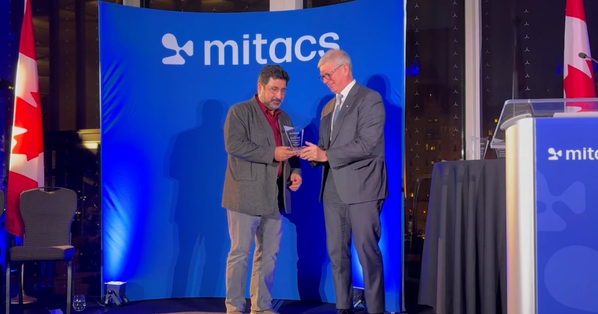
A professor from the University of Calgary, Faramarz Samavati, has been honored with the Mitacs Innovation Award for Outstanding Research Leadership for his pioneering work on a 3D digital mapping system. This recognition highlights his commitment to advancing technology and enhancing the accuracy of digital maps, a project he has dedicated 15 years to developing.
Samavati’s research addresses a significant limitation in current digital mapping applications, which often rely on a “flat Earth” model. This model can distort geographical representations, making places like Greenland appear much larger than they truly are compared to countries like Brazil. “Digital maps like Google Maps always have distortions,” Samavati explained. “When we visualize the Earth in 3D, we can accurately represent the true sizes of continents and avoid these inaccuracies.”
In collaboration with the Calgary-based software company Vivid Theory, Samavati and his graduate students developed a Discrete Global Grid System (DGGS). This innovative system divides the Earth’s surface into small grid cells, each assigned a unique code akin to a postal code. “This system allows for efficient data processing regarding Earth’s features, addressing the distortions inherent in traditional mapping,” he noted.
The research team, including graduate student Lakin Wecker, has focused on optimizing data access speeds. Wecker has been measuring processing times in nanoseconds, aiming to enhance the system’s efficiency. “We are measuring speeds that can reach 250 million times per second, looking to reduce processing times from 20 nanoseconds to 10 nanoseconds,” Wecker said. This level of precision is crucial given the vast amounts of data generated about the Earth.
Samavati’s work is further supported by a partnership with BigGeo, a Calgary-based startup developing the Spatial Cloud, a secure cloud computing system designed for location-based data. According to Brent Lane, CEO of BigGeo, “Spatial data accounts for 80 percent of all data on Earth, making it integral to the future of artificial intelligence.” Lane highlighted the potential of Samavati’s mapping system to provide users with faster and more accurate information for various applications.
The Mitacs Innovation Award is presented to a post-secondary supervisor who exemplifies strong collaboration with industry partners, offers valuable research experiences for interns, and leverages Mitacs funding to initiate impactful projects. These programs receive backing from the Government of Canada and various provincial governments.
Samavati envisions his mapping system not only as a tool for digitalizing the Earth’s surface but also for capturing what lies beneath and above it. “My goal is to create a living digital twin of the Earth,” he said. “This would allow us to gain a deeper understanding of our planet and develop tools to predict natural disasters—an essential capability in today’s world.”
For more information about BigGeo and its initiatives, visit their website at https://biggeo.com/.

iShares Core Dividend Growth ETF Faces Challenges; Alternatives Suggested

Discover 7 Scenic Hikes Near Calgary to Explore This Spring

Scientists Uncover Life’s Building Blocks in Ryugu Asteroid Samples

Windsor-Essex Unveils New Action Plan to Combat Substance Use

Boost Your Business Visibility with These Local SEO Strategies

East Algoma OPP Urges Public to Limit Travel Amid Hazardous Conditions

Universities Must Rethink Failure to Support Student Growth

Canada Invests $6.4 Million to Boost Green Shipping Corridors

Stony Plain Secures 14th Consecutive Award for Financial Reporting Excellence

Rhythm Pharmaceuticals Reports Strong Q4 Growth Ahead of FDA Decision

Brandon University’s Failed $5 Million Project Sparks Oversight Review

Microsoft Confirms U.S. Law Overrules Canadian Data Sovereignty

Winnipeg Celebrates Culinary Creativity During Le Burger Week 2025

New SĆIȺNEW̱ SṮEȽIṮḴEȽ Elementary Opens in Langford for 2025/2026 Year

EngineAI Unveils T800 Humanoid Robot, Setting New Industry Standards

Montreal’s Groupe Marcelle Leads Canadian Cosmetic Industry Growth
Tech Innovator Amandipp Singh Transforms Hiring for Disabled

Discover Aritzia’s Latest Fashion Trends: A Comprehensive Review

Dragon Ball: Sparking! Zero Launching on Switch and Switch 2 This November

Digg Relaunches as Founders Kevin Rose and Alexis Ohanian Join Forces
-
 Education7 months ago
Brandon University’s Failed $5 Million Project Sparks Oversight Review
-
 Science7 months ago
Microsoft Confirms U.S. Law Overrules Canadian Data Sovereignty
-
 Lifestyle7 months ago
Winnipeg Celebrates Culinary Creativity During Le Burger Week 2025
-
 Education7 months ago
New SĆIȺNEW̱ SṮEȽIṮḴEȽ Elementary Opens in Langford for 2025/2026 Year
-
 Business4 months ago
EngineAI Unveils T800 Humanoid Robot, Setting New Industry Standards
-
 Health8 months ago
Montreal’s Groupe Marcelle Leads Canadian Cosmetic Industry Growth
-

 Science8 months ago
Tech Innovator Amandipp Singh Transforms Hiring for Disabled
-
 Lifestyle3 months ago
Discover Aritzia’s Latest Fashion Trends: A Comprehensive Review
-
 Technology7 months ago
Dragon Ball: Sparking! Zero Launching on Switch and Switch 2 This November
-
 Technology2 months ago
Digg Relaunches as Founders Kevin Rose and Alexis Ohanian Join Forces
-
 Top Stories3 months ago
Canadiens Eye Elias Pettersson: What It Would Cost to Acquire Him
-

 Health6 months ago
Eganville Leader to Close in 2026 After 123 Years of Reporting
-
 Education7 months ago
Red River College Launches New Programs to Address Industry Needs
-

 Lifestyle2 weeks ago
Canmore’s Le Fournil Bakery to Close After 14 Successful Years
-

 Business7 months ago
Rocket Lab Reports Strong Q2 2025 Revenue Growth and Future Plans
-

 Top Stories3 months ago
Nicol Brothers Shine as Wheat Kings Dominate U18 AAA Hockey
-

 Business7 months ago
BNA Brewing to Open New Bowling Alley in Downtown Penticton
-
 Education5 months ago
Alberta Petition Aims to Redirect Funds from Private to Public Schools
-

 Technology6 months ago
Discord Faces Serious Security Breach Affecting Millions
-

 Technology8 months ago
Google Pixel 10 Pro Fold Specs Unveiled Ahead of Launch
-

 Education7 months ago
Alberta Teachers’ Strike: Potential Impacts on Students and Families
-

 Lifestyle5 months ago
Edmonton’s Beloved Evolution Wonderlounge Closes, New Era Begins
-

 Business7 months ago
Iconic Golden Lion Restaurant in South Surrey to Close After 50 Years
-

 Science7 months ago
China’s Wukong Spacesuit Sets New Standard for AI in Space